 Septian Primade

GIS & Spatial Analysis Specialist
Septian Primade
Contact: +62 812-1026-7900 | Email: sepfrim@gmail.com | LinkedIn
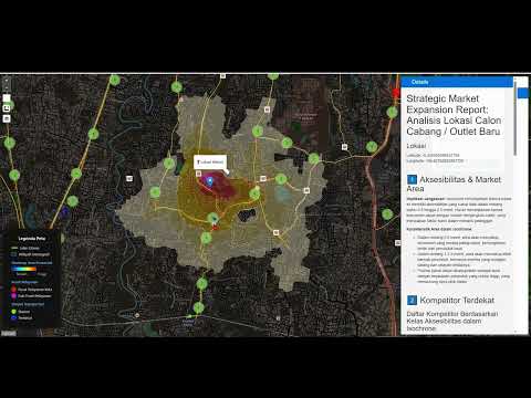
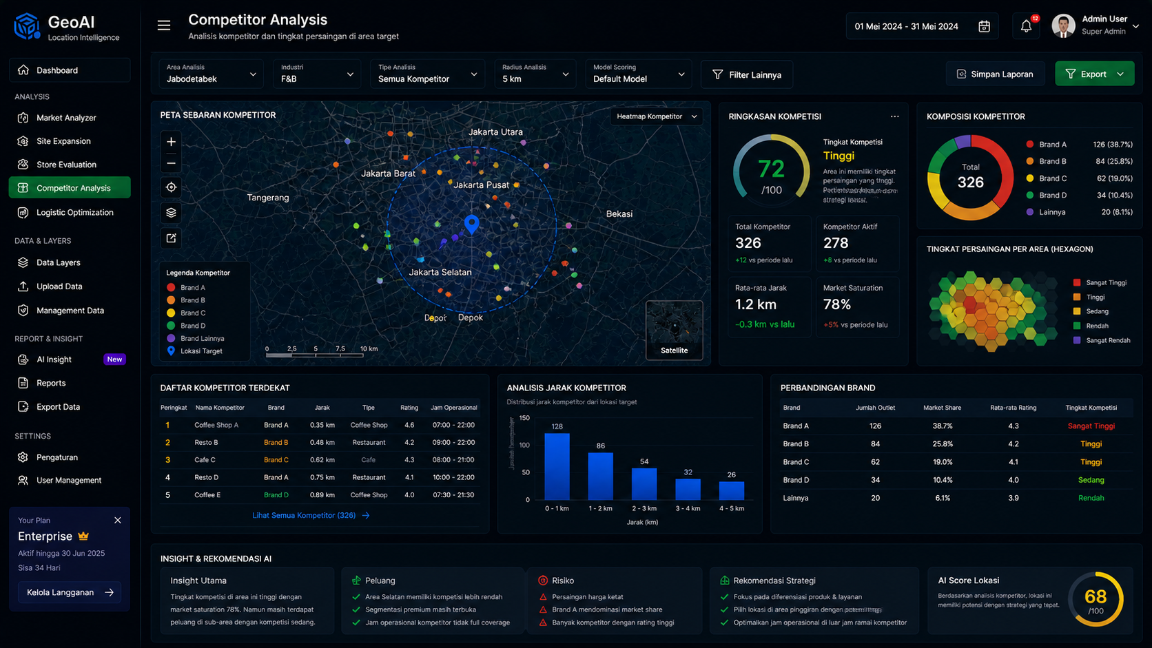
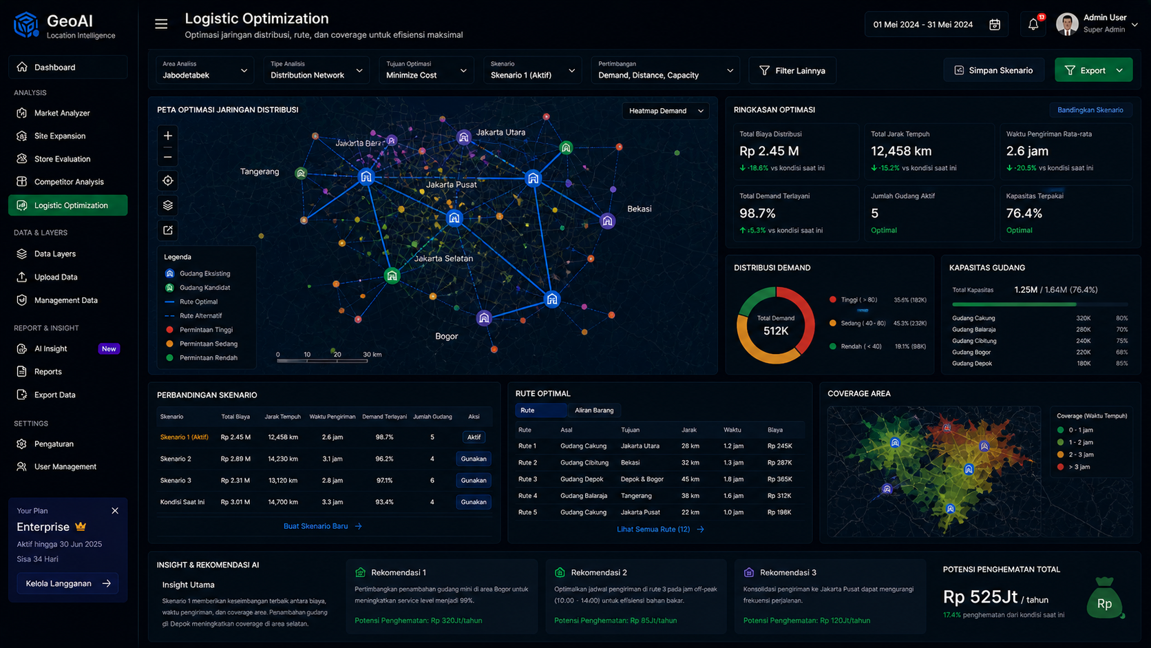
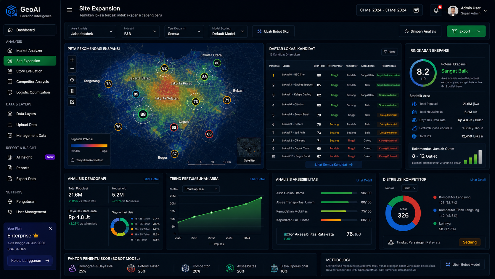
Market Analyzer empowers decision-makers to evaluate locations faster, more accurately, and with greater confidence — using real-world accessibility, spatial intelligence, and AI-driven strategy.
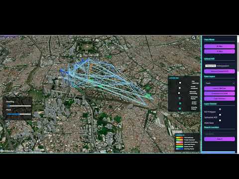
Urban AI 3D is a location intelligence platform developed to simplify urban analysis into a single integrated workflow by combining Leaflet, OpenStreetMap, Cesium Ion, and OpenAI to produce actionable insights, live data extraction, and AI-generated reports.
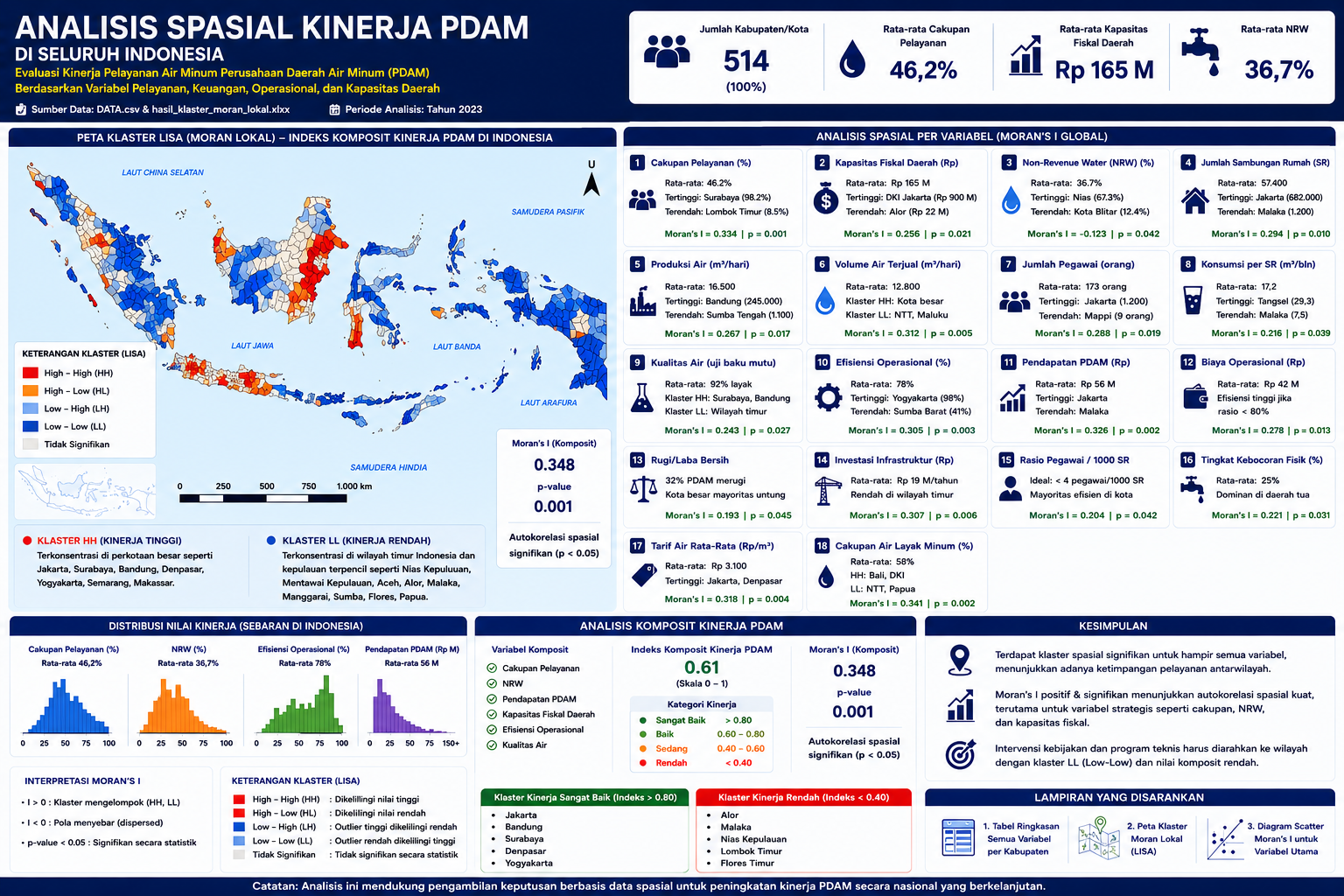
Spatial econometrics analysis in the Java–Bali SPAM study demonstrates the ability to integrate spatial statistics, geospatial visualization, and regional performance modeling to identify disparities in PDAM services across districts and cities. Using Moran’s I and LISA cluster analysis, the study reveals significant spatial autocorrelation in strategic variables such as service coverage, NRW, fiscal capacity, operational efficiency, and water quality. Major urban areas including Jakarta, Surabaya, Bandung, and Denpasar form High–High (HH) clusters with strong performance, while eastern regions tend to form Low–Low (LL) clusters. The analysis supports evidence-based policy intervention, infrastructure prioritization, and sustainable regional water service planning.
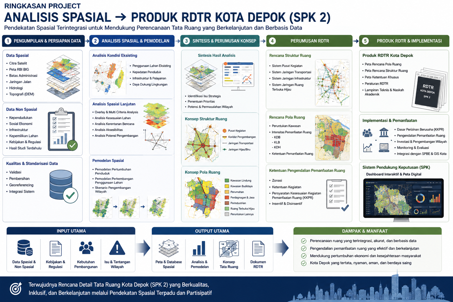
My capability in spatial analysis extends from data integration, GIS modeling, and regional planning analysis to the development of final planning products such as the Detailed Spatial Plan (RDTR) for Depok City SPK 2. This project demonstrates the ability to process spatial and non-spatial datasets, conduct overlay analysis, land suitability assessment, infrastructure and accessibility evaluation, as well as development scenario simulations to identify strategic urban issues and growth patterns. The analytical results are translated into structure plans, zoning concepts, land-use regulations, and GIS-based planning outputs. The final product includes official RDTR zoning maps, planning regulations, technical documents, and decision support systems that support sustainable, integrated, and data-driven urban spatial planning.
*Peta Hasil Pola Ruang Kota Depok SPK II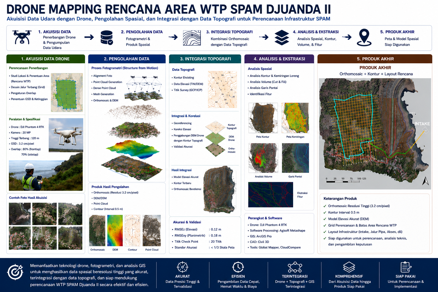
The "Drone Mapping Rencana Area WTP SPAM Djuanda II" project demonstrates an integrated GIS and drone-based spatial mapping workflow for infrastructure planning and technical analysis. The process includes drone flight planning, aerial data acquisition, photogrammetry processing, orthomosaic generation, DEM creation, contour extraction, and integration with topographic datasets. Advanced spatial analysis is applied to evaluate terrain conditions, elevation, slope, drainage patterns, and infrastructure accessibility around the planned Water Treatment Plant (WTP) area. The final product combines high-resolution orthomosaic imagery, contour maps, and planning layouts into a comprehensive spatial dataset that supports engineering design, decision-making, feasibility studies, and sustainable SPAM infrastructure development.

Septian Primade is a highly skilled GIS & Spatial Analysis Specialist with a strong academic foundation in Geography (B.Sc.) from the University of Indonesia and over a decade of professional experience delivering geospatial solutions across strategic sectors. He possesses deep expertise in GIS, remote sensing, UAV photogrammetry, geostatistics, and spatial econometrics, combined with advanced capabilities in WebGIS development using GeoServer, PostgreSQL/PostGIS, and OpenLayers, as well as programming in Python and R for data analysis and automation. Throughout his career, he has contributed to large-scale, high-impact projects, including detailed spatial planning, large-scale base map development, forestry mapping, and feasibility studies and engineering design for water supply (SPAM) and wastewater systems. His experience also spans geospatial database management, environmental and geological surveys, land acquisition mapping, and regulatory compliance in forest and peatland areas. With a powerful blend of technical expertise, analytical thinking, and policy understanding, Septian excels at transforming complex, multidisciplinary data into actionable spatial intelligence, enabling data-driven decision-making, innovative spatial planning, and the development of real-world GIS applications.
- Geographic Information Systems (GIS) & Remote Sensing
- Spatial Econometrics & Spatial Analysis with Python/R
- UAV Photogrammetry & Topographic Survey
- Environmental and Geological Surveying
- WebGIS Development (GeoServer, PostgreSQL, OpenLayers)
- Land Acquisition & Regulatory Compliance (Forest Areas, Land Ownership, Peatland Moratorium)
- Feasibility Studies and Engineering Design Support
- Data Management & GIS Database Administration
- WebGIS and GeoServer Implementation
- Internet Mapping with GeoServer, PostgreSQL, and OpenLayers
- Spatial Analyst with Python and R
- Basic Drone Remote Pilot
PT. Sinergis Pratama Geosolusi, Jakarta
- Led multiple mapping and spatial analysis projects.
- Landsat Imagery Interpretation for Forestry (West Kalimantan)
- Detailed Spatial Plan Project Depok City
- Toponymy Mapping for Depok City
- Development of 1:5,000 Base Map for Depok City
- Mapping for the National SPAM Project
- Advanced data analysis to support Spatial Econometrics studies
Rio Pakava District, Donggala Regency
- Collected satellite imagery, survey data, and aerial photos.
- Produced detailed spatial planning maps, integrating regulatory frameworks and spatial zoning.
SPAM-REG Ir. H. Djuanda II (Jakarta, Bekasi, Bogor)
- Managed geographic data acquisition and verification.
- Built GIS databases and produced thematic maps supporting feasibility and design documentation.
Semarang City Wastewater Management Project (Central Java)
- Applied GIS tools to analyze site conditions.
- Processed satellite imagery, surveys, and aerial photographs for wastewater system design.
Eastern Indonesia Water Supply Development (Sulawesi, Gorontalo)
- Conducted geospatial data collection and verification.
- Supported engineering design through detailed mapping.
Depok City Information Center (IDSD Project)
- Managed geospatial database integration and survey data.
- Produced georeferenced datasets for city planning.
PT. Redbit Teknologi Indonesia, Jakarta
- Analyzed spatial data for trend detection and decision-making.
- Produced thematic maps for crime statistics and healthcare accessibility.
PT. Menteng Kencana Mas (Sawit Sumber Mas Sarana Group), Central Kalimantan
- Supported plantation planning, monitoring, and evaluation.
- Conducted land acquisition mapping and compliance checks against forestry and peatland regulations.
PT. Virama Karya, Palembang (South Sumatra)
- Conducted land inventory for acquisition.
- Supported mapping for Palembang–Indralaya Toll Road development.
PT. Intan Prima Metalindo, Jakarta
- Geological and geoelectrical survey for coal and gold potential (North Bengkulu, Kupang, East Nusa Tenggara).
- Drilling observation and mapping of mineral deposits.

Bachelor of Science (Geography) – University Of Indonesia
- GIS Software: ArcGIS, QGIS
- Remote Sensing: Landsat, UAV photogrammetry
- Databases: PostgreSQL/PostGIS, GeoServer
- Programming: Python, R (Spatial Analysis, Modeling, Automation)
- Visualization: WebGIS, Spatial Dashboards, Interactive Mapping
Septian Primade
📞 +62 812-1026-7900
✉️ sepfrim@gmail.com
🔗 LinkedIn Profile
Professional Profile
GIS Specialist with expertise in spatial analysis, remote sensing, UAV photogrammetry, geostatistics, WebGIS, and geoinformatics for infrastructure, environmental, and urban planning.